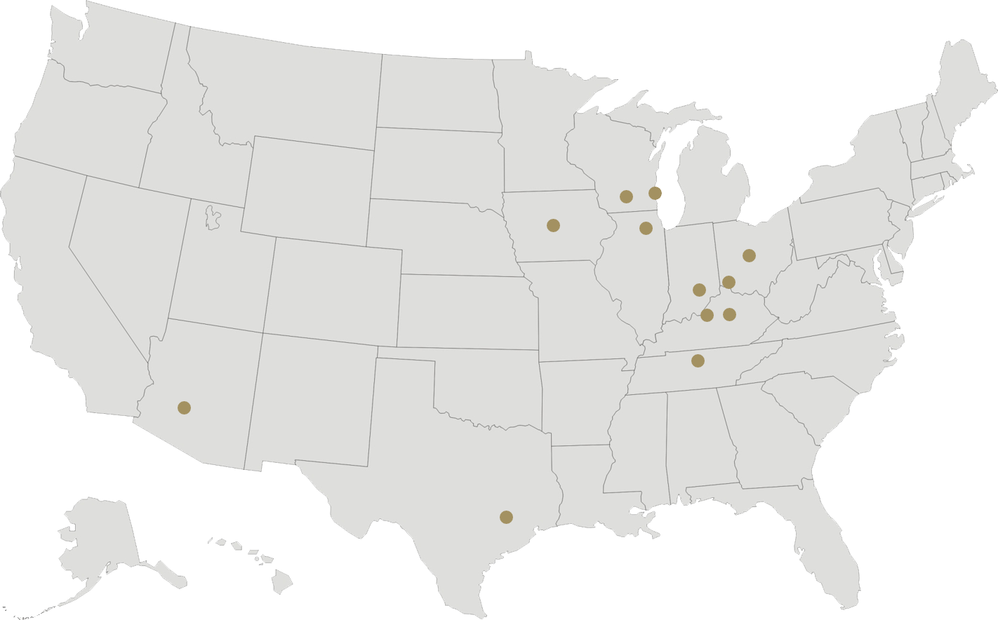
Established in 1946, we are a dynamic firm with 12 offices across the country and have completed projects in 48 states. The most recent Engineering News-Record Top 500 Design Firms ranking, based on billings, has us at 173.
Our staff consists of ...
“Our primary goal is to do everything we can to help our clients succeed. For our staff, this creates a challenging and rewarding environment and greater understanding of the professional service aspect of engineering. We are proud of the fact t...
Awards and Recognition Demonstrate Leadership in Evolution and Application of Innovative Technology
Our designs have gained local and national acclaim, and our firm has consistently been included in Engineering News-Record’s annual list of the “Top 500 ...
Events, Presentations, and Booth Exhibits
Our staff is active professionally. We attend conferences to expand our knowledge, stay at the forefront of technology and solutions, and share our expertise and experiences through presentations showcasing...
As municipal engineers, our involvement with local governments varies with the needs of each community. For many, we serve as the designated city, town, or village engineer providing comprehensive engineering services, including attending public meetings...
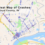
Geographic Information Systems (GIS) and computerized mapping focus on two broad areas. The first, manages facilities and records. It links databases such as tax records, water billing addresses, sewer locations, and other types of infrastructure records...
We have extensive experience with wastewater conveyance systems and pumping stations. This includes extension and/or reinforcement of existing collection systems, as well as complete planning, design, and construction supervision for new multimillion-dollar...
Much of our wetland work involves delineating and assessing impacted wetlands, implementing appropriate avoidance techniques, and developing innovative restoration methodologies. We are active in planning and designing restoration/enhancement projects...
We have been providing engineering services for natural gas distribution systems since the early 1980s. We have the expertise and experience to assist communities that operate their own natural gas distribution systems. Many of our clients have their...
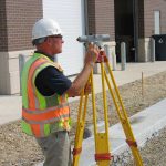
We own state-of-the-art electronic surveying instruments and utilize computer-based coordinate geometry and surveying programs in the execution of surveying work.
Our state-of-the-art equipment includes the new generation high-definition survey system,...
We understand that effective stormwater management involves an understanding of the nature and effectiveness of various methods of conveying and treating stormwater.
Services We Provide Include...
Analysis.
Plan development.
Design.
...
As a full-service engineering firm, it is our practice to follow projects through to completion of construction, providing the staff necessary to perform office and field activities. We are regularly involved with contract administration and construction...
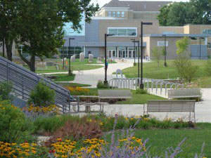
We regularly assist clients with redevelopment and urban renewal of existing downtown corridors and city streetscapes. As a full-service firm, we can address diverse engineering needs and serve clients during all phases of project development.
Services...
We provide a host of civil engineering services for development projects. Since 1968, we have provided a full range of services for both private- and public-sector clients.
Services We Provide Include...
Land development assistance.
Boundary...
We are able to assist communities with capital improvement planning and selection of financing methods. We are familiar with state and federal grant programs and local funding methods, including TIF districts, and various bonding and borrowing plans....
We recognize that no matter how effective a potential stormwater management solution may be, if it cannot be funded, it cannot be built. We have experience with a number of available potential funding sources, including creation of stormwater utilities.
Many...
We provide a variety of asset management services to assist clients in effectively managing infrastructure assets within the financial constraints of program budgets. Proactive asset management is cost effective and replaces operating in an emergency-...
Our Green Infrastructure Solutions group draws from all of our areas of expertise — wastewater, stormwater, municipal, transportation, water supply, and buildings and facilities — to provide specialized services that meet the continually evolving nee...
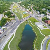
Watershed planning is the foundation for the successful management of any stormwater program, whether small or large. Our expertise in regional watershed planning includes hydrologic and hydraulic modeling of watersheds of various sizes, urban and rural...
Our Green Infrastructure Solutions group has extensive expertise in all aspects of sustainable stormwater controls and green infrastructure best management practices (BMPs). Areas of expertise include design of:
Rain gardens
Porous pavements...
Sustainable transport systems are becoming increasingly important initiatives locally, regionally, and nationally. Transport systems have significant impacts on the environment, accounting for nearly 25 percent of the world’s energy consumption and c...
One of our many specialties is combatting erosion and providing flood relief through naturalized stream restoration design. In many cases, the waterway is experiencing hydromodification issues because of upstream urban development, requiring an in-field...
As national stormwater regulations become more stringent, we have assisted clients with cost-effective permit compliance strategies. Our MS4 compliance services have included permit negotiations, development of stormwater management plans, creation of...
Reducing energy consumption and incorporating energy efficient and renewable energy technologies in existing or proposed facilities is like putting money back in the client’s pockets. We consider and identify practical and measurable green facility d...
We are regularly involved with contract administration and construction observation services for green infrastructure projects. Construction oversight of green projects is one of the most critical and often overlooked steps in achieving a successful project....
We have distinguished ourselves as leaders in sustainable planning, particularly as it relates to regional master planning efforts targeting issues such as combined sewer overflow reduction, stormwater management, transportation networks, and community...
Across the country, municipalities are facing incredibly high costs to reduce their combined sewer overflows (CSOs) and sanitary sewer overflows (SSOs). We provide a wide range of services to assist clients with CSO and SSO compliance, such as consent...
Our green infrastructure services include full-service design of green buildings and facilities that incorporate state-of-the-art features aimed at creating more sustainable spaces. Our designs have incorporated elements such as geothermal heating and...
We provide a variety of asset management services to assist clients in the critical task of effectively managing green infrastructure assets within the constraints of fiscal budgets. We help clients develop programs that anticipate potential infrastructure...
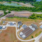
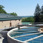
We have engineered wastewater treatment and biosolids management projects for large and small municipalities and industries as well as sanitary districts, towns, villages, and institutions throughout the United States, with concentration in the states...
Wastewater engineering has been a core service provided by our firm since our establishment in 1946. Our success has been attributed to sound application of engineering principles, which leads to well-designed and operated WWTPs and conveyance facilities....
We have extensive experience with dynamic modeling of hydraulically-complex wastewater collection systems. Models we use include XPSWMM, SewerCAD, InfoWorks, Hydra, and simple spreadsheets. The impact of wet-weather events (rainfall and snow melt) upon...
We are continually involved in construction-related services on projects designed by our firm and by others. As a full-service firm, it is our practice to follow our projects through to completion of construction and provide the staff necessary to perform...
Prior to beginning design of most significant conveyance projects, we complete a comprehensive report or planning study to identify current and future conveyance facility needs. These reports and studies are often preceded by extensive flow monitoring...
We have specialized in environmental consulting for more than 70 years and are well qualified to complete many types of environmental science and engineering projects related to surface and groundwater quality. We have the capabilities to perform watershed...
Permitting assistance can significantly reduce compliance costs and keep projects moving forward. As a leader in the wastewater industry, we regularly assist clients with a wide range of permitting issues associated with the construction of wastewater...
One of our areas of specialization in the environmental engineering field is conveyance and pumping of wastewater and stormwater, as either combined sewer or separate sanitary and stormwater systems. Our experience includes a wide range of projects, from...
We offer various compliance services that enable facilities to comply with local, state, and federal regulations, while realizing cost savings through operational changes, and identify practices that have high environmental liability. Typical environmental...
Wastewater process modeling has become a key tool in the efficient and effective design of modern wastewater treatment facilities, and we have been using computer-generated process modeling for wastewater projects for more than a decade. We have extensive...
We provide a variety of asset management services to assist clients in the critical task of effectively managing wastewater infrastructure assets within the constraints of fiscal budgets. We help clients develop programs to anticipate potential infrastructure...
Water supply is a major focus of our environmental services. We provide a complete range of supply, storage, pumping, distribution, treatment, security, and supervisory system control services, from planning phase, through design, and into construction....
Aging infrastructure, changes in water chemistry, and switching sources are some of the many circumstances that may lead to water distribution system corrosion or scaling. Our qualified staff has assisted numerous Utilities in evaluating the potential...
Whether groundwater or surface water, our engineers are routinely assisting clients with investigating, testing, and developing new sources of water supply. We have designed more than 100 new water wells, from shallow sand and gravel wells, to intermediate-depth...
Our water main work has ranged from threading replacement mains through existing utility-crowded streets to preparing plans for new subdivisions to allow critical development to proceed. Our projects have included everything from extension of mains to...
We are recognized as experts in the analysis and evaluation of water systems through master planning.
We have conducted many master planning efforts for communities with populations of 400 to major metropolitan areas. Water system master planning establishes...
Considered experts in water treatment, our engineers have the experience needed to implement treatment strategies to handle issues ranging from simple nuisance contaminants to complex problems such as VOCs, PFAS, and challenging surface water sources.
The...
Engineering services performed during construction are critical to project success. Our engineers and technicians have the experience needed to look out for the interests of our clients throughout construction. From office work to onsite construction...
A water model can help identify deficiencies in current systems and prepare for future system expansion. Often, a community knows the issues present in its system, such as high or low pressures, inadequate fire supply, water hammer, or frequent water...
Throughout our history, we have designed countless water storage facilities, including tanks of different shapes, styles, and sizes. Our elevated storage experience ranges from modern single-pedestal tanks to simpler standpipes, with tank sizes ranging...
We provide a variety of asset management services to assist clients in the critical task of effectively managing water infrastructure assets within the constraints of fiscal budgets. We help clients develop programs that anticipate potential infrastructure...
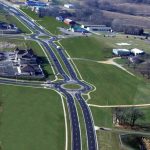
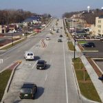
Our transportation services include planning, designing, and administering construction of local streets and rural highways, major urban arterials, U.S. and state highways, tollways, and the interstate system. Services on these projects have included ...
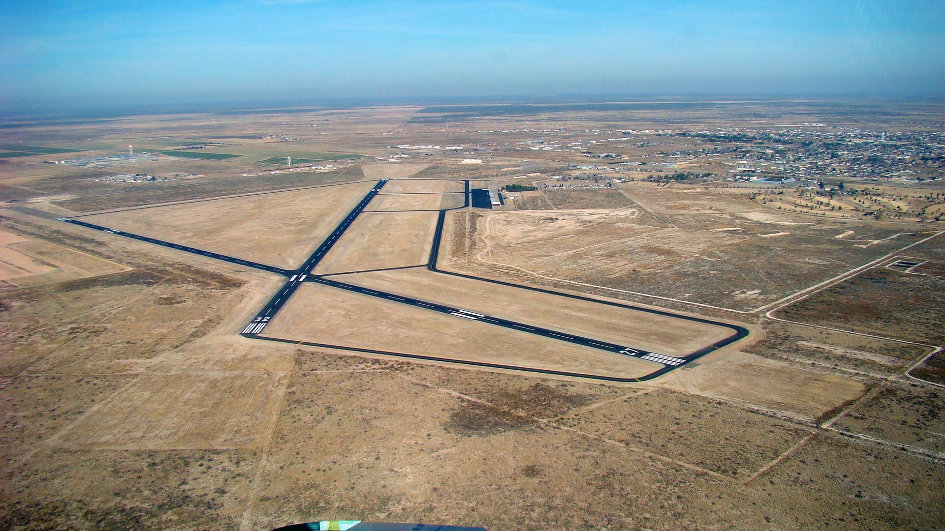
Our aviation services include plan development, design, and construction management for general aviation (GA) airports. We are experienced in applying Federal Aviation Administration (FAA) and state DOT guidelines to accomplish GA airport improvements. ...
Proper airfield pavement rehabilitation is a process that involves budget availability, materials testing, alternatives analysis, detailed specifications, and construction management. Our firm has designed pavement rehabilitation improvements for more ...
Our firm has led and prepared several Airport Development Plan (ADP) reports, wherein we provide airport owners airport management tools and detailed guidance for airport infrastructure development for typical 10-15 year periods. These reports have mirrored...
Runway and parallel taxiway extensions, as well as apron expansions, are made primarily based on aircraft demand. Our firm has designed these infrastructure improvements for aircraft ranging from 12,500-pound single wheel to 90,000-pound dual-wheel loadings,...
Revenue-producing infrastructure development greatly assists airport owners in providing long-term cash flows. These constant revenues aid airport owners in solidifying local political support for their airports and help fund needed future pavement rehabilitation...
Typical GA airport lighting includes rotating beacons, lit wind cones, edge/threshold lighting, guide signs, approach lighting, electrical vaults/equipment, security lighting, backup generators, and LED lighting (when appropriate to reduce maintenance...
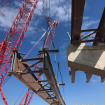
We provide plan development, design, and construction services for bridges. After an in-depth inspection, anticipated costs have often justified rehabilitation over replacement. This option saves money and often can extend the life of the structure another...
Bike and pedestrian paths are often accommodated as part of our road projects as well as stand-alone projects. These facilities accommodate a mix of users, including bikers, pedestrians, joggers, wheelchairs, baby strollers, inline skaters, etc. We pay...
We provide engineering design and construction-related services for a wide array of tollway projects. We have designed new superstructures, as well as the rehabilitation of existing superstructures for over and under-passes, and noise abatement facilities.
Services ...
Successful roundabout solutions require specialized expertise that is based on both qualitative guidelines and specific standards. As a nationally recognized expert, our engineers understand the importance and interdependence of the sizing, markings,...
Our staff helps DOTs and counties maintain and enhance rural highway systems. We are fully knowledgeable about federal funding requirements and can help clients with projects ranging from resurfacing to multi-lane freeway/expressway conversion.
Our...
We help clients succeed in delivering high-quality urban freeways, whether it is through expansion, reconstruction, or rehabilitation.
Our Unique Value Includes...
Complex interchange design
System
Single-point urban interchange (SPUI)...
We regularly provide contract administration and construction observation services for federal, state, toll, and locally funded projects. Our construction-related services apply to a wide variety of projects, including rural and urban highways and bridges, ...
We build stakeholder relationships with local planners, transportation professionals, city administrators, and the public that are inclusive, productive, up-front, and at a level appropriate for the scope of the project. We present information accurately...
We have provided plan development, design, and construction services for a wide range of traffic signal projects. Our experience has included hundreds of permanent and temporary traffic signals, and the integration of innovative features, such as Adaptive...
We have been providing leading-edge traffic engineering and transportation planning services for more than 20 years. We take pride in the efficiencies resulting from our investment in technology and resources that enable us to share expertise among all...
We own state-of-the-art electronic surveying instruments and utilize computer-based coordinate geometry and surveying programs in the execution of our surveying work.
State-of-the-art equipment includes the new generation high-definition survey system...
We understand the importance of intelligent transportation systems (ITS) and its diverse applications. ITS systems can provide:
Measurable benefits to travelers.
Help minimizing traveler delay with reliable real-time route information.
Real-time...
We routinely complete right-of-way plats for various federal, state, and municipal projects. Plats are in conformance with the appropriate facilities development manuals and plat guides. Subdivision plats for developers and municipalities are completed ...
Our comprehensive engineering services have helped communities transform their urban arterials to accommodate multi-modal transportation and revitalize their downtown or commercial corridors.
Services We Provide Include...
Alternatives analysis...
We routinely guide clients through the regulatory process, helping them earn project approvals and preventing project delays. Our team of environmental specialists manages the process.
Services We Provide Include...
NEPA documentation
Categorical...
We provide a variety of asset management services to assist clients in the critical task of effectively managing transportation infrastructure assets within the constraints of fiscal budgets. We help clients develop programs that anticipate potential...
As a full-service engineering firm, we offer the convenience of one firm for all facilities and information technology (IT) needs. This includes complete planning, design, renovation and restoration, construction-related, and administration services....
We provide a full array of civil, structural, and architectural services for building and facilities projects. Our experience includes plan development, design, and bid and construction-related services for both public-and private-sector clients.
Services ...
Our mechanical, plumbing, and fire protection team has expertise with new designs, modifications, renovations, and upgrades. We routinely assist clients to enhance the performance and minimize energy costs of many types of mechanical systems.
Our ...
Our electrical staff has the expertise to meet the needs of today’s complex electrical systems. We can assist with needs ranging from energy evaluation and system plan development and design, to bid and construction-related assistance, for both private- an...
We provide plan development, design, and implementation services for Supervisory Control and Data Acquisition (SCADA) systems.
Services We Provide Include...
Evaluating existing systems for improvement or replacement
Developing system specifications...
We provide engineering and architectural plan development and design services for police, fire, and emergency medical services (EMS) departments and agencies. Our projects include greenfield facilities, existing station renovations, and historic building...
We provide engineering and architectural plan development and design for commercial office buildings, retail, and recreational facilities. Our projects include build-outs, modifications of existing facilities, and new building developments.
Our Unique...
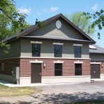
We have experience designing a wide variety of structures for civic and community needs, including municipal and vehicle storage facilities, public works and utilities buildings, and park shelters.
Our Unique Value Includes...
Full-service...
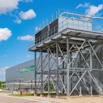
We provide architectural and engineering services for manufacturing facilities throughout the country. Our staff includes all architectural and engineering disciplines needed to provide a well-coordinated approach for projects. Projects include new,...
We have the expertise to meet the needs of today’s complex electrical systems. Our experience includes design of industrial, commercial, and municipal systems.
Our System Experience Includes...
High, medium, and low voltage power
Alternative a...
Information management and security continue to be extremely important as digital use and storage of data expands. Our information technology specialists provide the expertise to stay current with network and security system threats. Our experience i...
Refrigeration systems are typically complex cooling systems designed for large industrial or commercial operations. These systems require experience to plan, design, and implement effective additions or modifications. We offer that experience. We provide ...
Food and beverage facilities require a diverse team of skilled, industry-seasoned professionals experienced in facility, plant utilities, and power systems to support manufacturing needs. We provide solutions to minimize plant disruptions, provide...
Buildings and Facilities
Green Infrastructure
Municipal / General Civil
Transportation / Aviation
Wastewater
Water Supply
Our Staff is Comprised of Bright, Talented Professionals — Individuals with Diverse Backgrounds, Extensive Training, Specialties, and Broad Project Experience
Our Corporate Mission states, "... we are dedicated to helping clients succeed through e...
As a vibrant organization, we are continually accepting resumes from individuals enthusiastic about a career in civil, environmental, structural, electrical, transportation, and mechanical engineering.
Full-time employees are eligible to enroll in...
Corporate Headquarters
Madison, Wisconsin
910 West Wingra Drive
Madison, WI 53715
Phone: 608.251.4843
Fax: 608.251.8655
More Info
Arizona
Phoenix, Arizona
5029 East Sunrise Drive,...
Brenham, Texas
1906 Niebuhr Street
Brenham, TX 77833
Phone: 979.836.7937
Lexington, Kentucky
651 Perimeter Drive, Suite 220
Lexington, KY 40517
Phone: 859.225.8500
Cincinnati, Ohio
615 Elsinore Place, Suite 320
Cincinnati, OH 45202
Phone: 513.861.5600
Louisville, Kentucky
325 West Main Street, Suite 710
Louisville, KY 40202
Phone: 502.583.7020
Columbus, Indiana
629 Washington Street
Columbus, IN 47201
Phone: 812.372.9911
Columbus, Ohio
500 Neil Avenue, Suite 110
Columbus, OH 43215
Phone: 614.835.0460
Milwaukee, Wisconsin
126 North Jefferson Street, Suite 350
Milwaukee, WI 53202
Phone: 414.271.0771
Corporate Headquarters
910 West Wingra Drive
Madison, WI 53715
Phone: 608.251.4843
President and CEO : Matthew Richards, P.E.
Chairman: Theodore Richards
Phoenix, Arizona
5029 East Sunrise Drive, Suite 100
Phoenix, AZ 85044
Phone: 602.437.3733
Joliet, Illinois
1170 South Houbolt Road
Joliet, IL 60431
Phone: 815.744.4200
Ames, Iowa
2802 South Loop Drive
Ames, IA 50010
Phone: 515.233.0000
Nashville, Tennessee
501 Corporate Centre Drive, Suite 580
Franklin, TN 37067
Phone: 615.800.5888
Strand Associates Bid Documents - Quest
Brenham, TX Office Bid Documents - CIVCAST
Plan holders receiving drawings and specifications electronically from QuestCDN and CivCast are requested to provide an e-mail address if they wish to receive project...
We invest the time and energy to thoroughly understand each project for its functional, economical, political, and environmental impacts.
Our Corporate Mission states that we are dedicated to helping clients succeed through excellence in engineering....
Website Terms and Conditions of Use
The following states the terms and conditions under which users may use this website. Please read this information carefully. If a user does not accept the terms and conditions stated here, please do not use t...
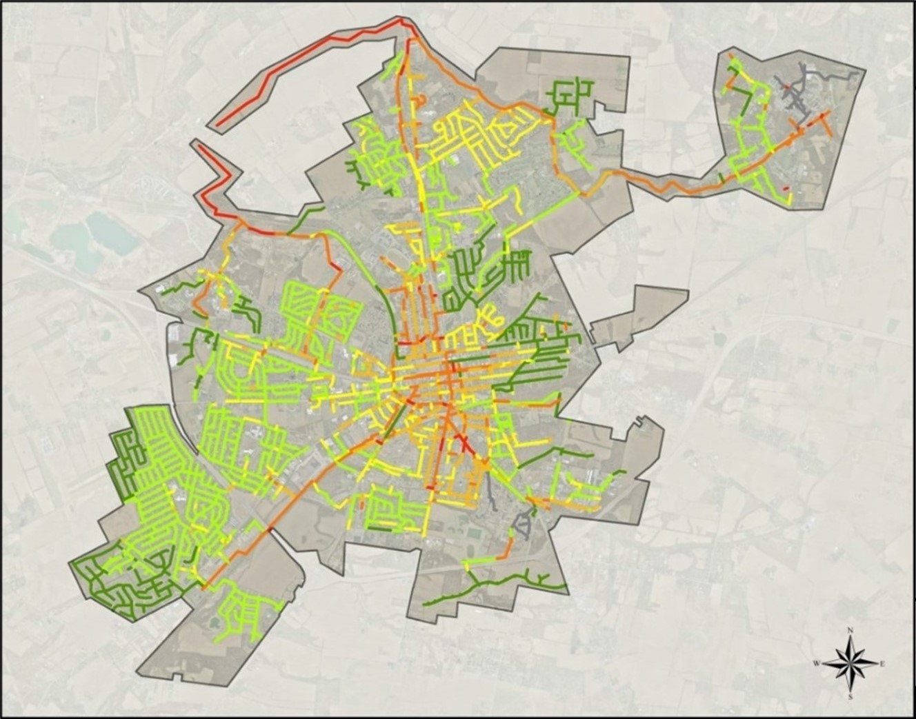 Geographic Information Systems (GIS) and computerized mapping focus on two broad areas. The first, manages facilities and records. It links databases such as tax records, water billing addresses, sewer locations, and other types of infrastructure records to a ‘map’. By joining the powers of a database with the visual acuity of a map, enormous potential is unleashed for facilities management and presentation of information. For example, sewer manholes needing repair can be queried, plotted, and used as a base for the current year’s maintenance program.